
My 3rd post on #Steemit was about all about Ladakh and gave an insight into why it is not only one of the most beautiful places on Earth but also makes up for an adventurous road-trip - Click here to read that post (its a long one!)

So while you cannot plan and execute a Ladakh trip in a matter of days, you can very well take a little virtual walk into how it looks. My last trip saw me traveling with four other friends turned guests from the city of Mumbai and one of them, Juzer, took stunning 360 degree shots of the landscape. These are high resolution images which give you an insight into how Ladakh looks like. Shall we start then?
FIRST

Location: Our campsite on Day 2 (Manali to Jispa)
Original 360 View: CLICK TO VIEW
SECOND

Location: Another view of our campsite on Day 2 (Manali to Jispa)
Original 360 View: CLICK TO VIEW
THIRD

Location: 1st stream crossing on Day 3 (Jispa to Leh)
Original 360 View: CLICK TO VIEW
FOURTH

Location: Enroute Baralacha la pass on Day 3 (tarmac was all set to disappear)
Original 360 View: CLICK TO VIEW
FIFTH

Location: Baralacha la pass on Day 3 - 4890 m / 16100 feet above sea level
Original 360 View: CLICK TO VIEW
SIXTH

Location: 'More Plains' on Day 3 - 4800 m / 15800 feet.
Original 360 View: CLICK TO VIEW
SEVENTH

Location: 'More Plains' on Day 3 - notice the wind formed sculptures in the valley below
Original 360 View: CLICK TO VIEW
EIGHTH
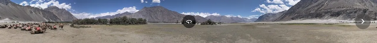
Location: Nubra valley on on Day 4 - you also find double hump bactrian camels here
Original 360 View: CLICK TO VIEW
NINETH

Location: Enroute Panong Tso lake on Day 5(via Agham-Shyok route). We came across a car every 20-30 mins. Its that secluded!
Original 360 View: CLICK TO VIEW
TENTH

Location: Panong Tso lake! This was shot in late evening with the full moon. Next image shows how the colors play around (evening vs morning)
Original 360 View: CLICK TO VIEW
ELEVENTH

Location: Panong Tso lake - in the morning. You can also see our orange cabins in the back-drop!
Original 360 View: CLICK TO VIEW
TWELFTH

Location: Enroute Hanle. We drove along the lake for about 30-40 minutes. Day 6.
Original 360 View: CLICK TO VIEW
THIRTEENTH

Location: Day 6, near Chushul (China border was about 8-9 km in a straight line). This is Rezang La War Memorial. And yes, this is a 'road' marked on maps (even Google Maps). Its complete isolation here.
Original 360 View: CLICK TO VIEW
FOURTEENTH

Location: Day 6 at Hanle. The 'fire in the sky' sunset image that I shared yesterday was captured here. We drove to this place to get a good voice signal for making calls back home!
Original 360 View: CLICK TO VIEW
FIFTEENTH

Location: Day 7 at Hanle. You need to take the road up here from the village incase you want to visit the world's second highest observatory - visible in the 360. Elevation - 15500 feet
Original 360 View: CLICK TO VIEW
SIXTEENTH

Location: Day 7 : Hanle to Tso Moriri lake. We walked up this little mountain to get a bird's eye view of the massive flood plains.
Original 360 View: CLICK TO VIEW
SEVENTEENTH

Location: Day 7 : Tso Moriri lake. We walked thru these lush green fields towards the lake. As you rotate the 360, you can see the little village of Karzok (white huts) in the back-drop.
Original 360 View: CLICK TO VIEW
EIGHTEENTH

Location: Day 7 : Tso Moriri lake in the evening. You can also notice the full moon here as well.
Original 360 View: CLICK TO VIEW
Are these images making up your mind for visiting Ladakh? In that case, do spend five minutes on this post I created yesterday : its got almost everything you need to know about this place - @bunnypunia/looking-at-the-most-epic-roadtrip-ever-welcome-to-18000-ft-5500-mtrs-welcome-to-ladakh-long-post
Thank you for reading this post - if you think this was useful, please vote it up and if you have any questions about Ladakh, feel free to ask :)